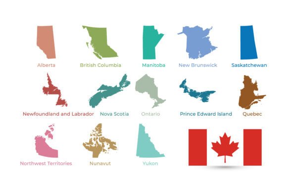
All Provinces and Territories of Canada
If you have ever needed a clear, professional, and visually appealing map of Canada, you have likely run into the same challenge: finding a resource that shows every province and territory in a way that is both accurate and easy to use. The All Provinces and Territories of Canada vector set solves exactly that. It is a colorful, modern collection of all 13 Canadian regions—Alberta, Ontario, Quebec, British Columbia, and every other province and territory—each uniquely colored and clearly labeled. The set also includes a Canadian flag illustration, which pairs nicely with the map for projects that need a complete national representation.
What makes this resource stand out is its simplicity. You do not need to be a professional designer or a geography expert to make good use of it. The files are provided in multiple formats—EPS, AI, PDF, and SVG—so you can open them in almost any design or document software. They come in high resolution, are print-ready, and are packed into a single ZIP archive for easy download and organization. Whether you are creating a classroom handout, a travel blog graphic, or a presentation slide, you have everything you need in one convenient package.
What This Vector Set Offers in Practical Terms
At its core, this set is a collection of map graphics that represent Canada in its entirety. Each province and territory is treated as a separate, editable element. This means you can change colors, resize, rearrange, or combine them with other visuals without losing quality. Because the files are vectors, they scale cleanly from a small icon on a website to a large poster without becoming pixelated or blurry.
The design is clean and modern. The colors are distinct, making it easy to tell one region from another at a glance. Labels are included directly on the map, so you do not have to wonder which area is Nunavut versus Northwest Territories. This attention to clarity makes the set especially useful for anyone who needs to communicate geographic information quickly and accurately.
For beginners, the ZIP archive eliminates confusion. You download one file, unzip it, and find all the formats ready to use. If you work with Adobe Illustrator, you will appreciate the AI file. If you prefer open-source tools like Inkscape, the SVG file works perfectly. For those who just need a quick PDF for printing or sharing, that option is there too. The EPS format is a reliable fallback for many older or professional design workflows.
Practical Uses Across Different Contexts
One of the biggest appeals of this resource is how many different situations it fits into. Here are some realistic ways people use it:
- Educational materials: Teachers and homeschool parents can create worksheets, quizzes, or wall posters that show all provinces and territories. The clear labels help students learn the names and locations without confusion. A geography lesson on Canadian regions becomes much more engaging when you have a colorful, accurate map to work with.
- Infographics and data visualization: If you are a blogger or marketer creating content about Canada—whether it is population statistics, climate data, or travel trends—you can use the map as a base layer. Color-code each region differently, add data points, and produce a professional-looking infographic without starting from scratch.
- Travel posters and itineraries: For travel bloggers, tour operators, or anyone in the tourism industry, a visually appealing map of Canada helps visitors understand where destinations are located. You can highlight specific provinces, mark routes, or create a poster that shows the breadth of what Canada has to offer.
- Presentations and reports: Business professionals, entrepreneurs, and consultants often need to present information about Canadian markets, operations, or demographics. Having a clean map that you can drop into a slide saves time and adds a polished look to your work.
- Design projects and merchandise: Freelancers and hobbyists can use the vector files to create custom merchandise like T-shirts, mugs, or prints. Because the files are fully editable, you can tweak colors, remove labels, or combine the map with other design elements to suit your style.
The included Canadian flag illustration is a thoughtful addition. It complements the map nicely for projects that need a strong national identity, such as Canada Day materials, immigration resources, or patriotic branding.
Who Benefits Most from This Resource
This vector set is designed for a broad audience, but certain groups will find it especially valuable:
- Educators and students: Whether you teach elementary social studies or a college-level Canadian studies course, having a reliable, attractive map saves preparation time and improves learning outcomes.
- Content creators and bloggers: If you write about Canadian travel, culture, or business, a high-quality map adds credibility and visual interest to your articles and social media posts.
- Small business owners: If your business operates across Canada or targets Canadian customers, you can use the map for reports, proposals, or marketing collateral that shows your geographic reach.
- Freelance designers: Having a ready-to-use vector map of Canada in your toolkit means you can take on projects faster. You no longer need to trace or recreate a map from scratch every time a client needs one.
- Hobbyists and DIY enthusiasts: Whether you are crafting a custom calendar, making a family trip planner, or designing a gift for a geography enthusiast, these files give you a professional starting point.
Important Considerations Before Using the Set
Before you dive into a project, there are a few things worth keeping in mind to get the best results from this resource.
First, because the files are vectors, you will need compatible software to edit them. AI and EPS files work well in Adobe Illustrator, CorelDRAW, and similar programs. SVG files are more flexible and can be opened in many free tools like Inkscape or even web browsers for basic viewing. PDF files are ideal if you just need to print or share without editing. If you are new to vector graphics, starting with the PDF or SVG format may be the easiest path.
Second, consider the purpose of your project. The map labels each province and territory, which is great for educational and informational uses. However, if you plan to use the map as a background or part of a larger design, the labels may interfere with your layout. Fortunately, because the files are editable, you can remove or reposition labels as needed. This flexibility is one of the biggest advantages of working with vector files.
Third, think about color consistency. The set uses distinct colors for each region, which helps with identification. If you need the map to match a specific brand palette or a particular theme, you can recolor individual provinces without affecting the rest. This is especially useful for businesses or projects that require a consistent visual identity.
Fourth, check the resolution requirements for your intended use. The files are print-ready and high-resolution, so they will work well for most print applications like posters, handouts, or banners. For large-scale printing, such as billboards or trade show displays, you may need to test the scaling to ensure the labels remain legible. Because they are vectors, scaling up is generally fine, but small text can become proportionally large in extreme enlargements.
Finally, keep in mind that this set is designed to represent the provinces and territories of Canada in a straightforward, modern style. If you need a highly detailed topographic map or a map showing cities, roads, or natural features, you may need a different resource. This set excels at being a clear, clean, and immediately useful representation of political boundaries and regional divisions.
Getting Started with Confidence
For anyone who has ever felt overwhelmed by finding the right map for their project, this resource removes a lot of the guesswork. You get all the major formats, a clean design, and the complete coverage of every province and territory in Canada. The inclusion of the Canadian flag adds a nice finishing touch for projects that call for national pride or identity.
Beginners will appreciate how easy it is to get started: download the ZIP, extract the files, and open the format that works best for your software and skill level. Professionals will appreciate the editability and the time saved by not having to create a map from scratch. Whether you are preparing a classroom lesson, building a travel blog, designing a poster, or creating a business presentation, having a reliable vector map of all Canadian provinces and territories at your fingertips makes the process smoother and the result more polished.
The key is to match the resource to your specific need. If you need a clear, colorful, and easy-to-read map that you can adapt quickly, this set delivers exactly that. Take a few minutes to explore the files, test them in your preferred software, and see how they fit into your workflow. With a little experimentation, you will likely find multiple ways to put them to good use.